Ingleborough
Ingleborough, from Whernside
Location (summit): SD 741 746
Getting there: Depends on route you wish to take. There are car parks in Clapham, Ingleton and Horton-in-Ribblesdale, plus parking at Ribblehead viaduct. For public transport, Ingleton has decent bus links, and there are train stations nearby in Horton and at Ribblehead.
Height (marked by trig point on summit): 723m (nearby cairn marked as 724m!)
Map: OL2 Yorkshire Dales (Southern and Western Area) (get it here)
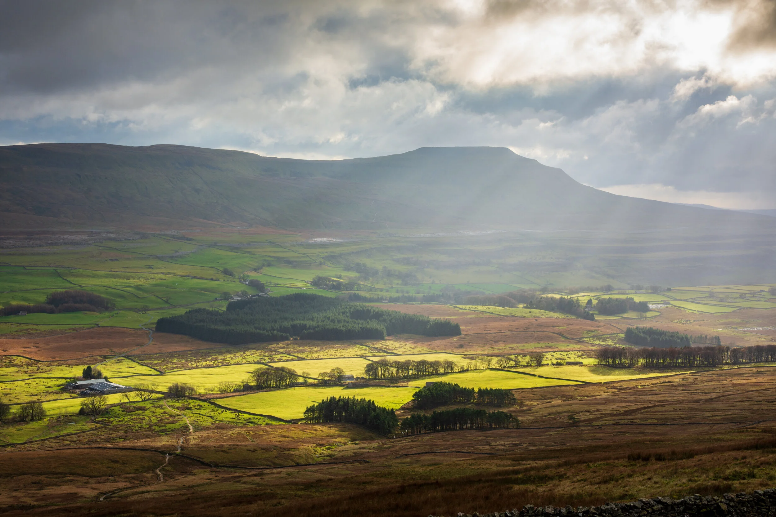
A firm favourite of many, this instantly recognisable peak in the Yorkshire Dales provides not only a challenging hill walking experience but also plenty of natural sites and ancient history.
Ingleborough makes up one of the Yorkshire Three Peaks - the last one on the traditional route, and this, along with the multiple scenic approaches makes the hill very popular. You’re unlikely to get the summit to yourself, but away from the main Y3P route, you’ll find paths steadily busy, rather than packed.
The summit is a curious place, a large flat plateau which aids Ingleborough’s distinctive appearance. The entire summit was once a fort, likely constructed in the Iron Age, and the rocks found on the summit are largely the remains of this settlement. A rubble rampart encircled the entire plateau, with at least 20 stone huts, between 5m and 8m in diameter within the walls. Despite the massive effort to construct such a site, the fort was unlikely to have been only a seasonal residence, with severe weather the norm, and no fresh water available. That said, it was likely an imposing site to those below, and projected its power throughout the Roman occupation and into the Dark Ages, when it fell into disrepair.

It’s easy to see why Ingleborough became an ancient cultural centre. Whernside is in the background
It is from this fort that the hill gets its name, with Ingleborough, literally meaning ‘Hill Fort’
On a clear day, the summit offers a splendid panorama, with the mountains of Snowdonia and allegedly Snaefell, on the Isle of Man, visible. I’m not sure about that, but the Lake District fells and Morecambe Bay feel fairly close, along with many neighbouring peaks in the Dales.

The flat summit of Ingleborough
The geology of Ingleborough contributes to its unique shape, with a bed of permeable limestone, ‘The Great Scar’ sitting beneath layers of shale and sandstone, with the protruding summit made up of stable Millstone Grit. It is believed that another layer of softer rock sat above the summit, but this was eroded away, leaving the plateau behind.
The limestone layer gives the lower slopes many of their dramatic features, from limestone pavements, which surround the hill on three sides, to potholes, to caves and cave systems, like the magnificent Gaping Gill, White Scar caves, and Ingleborough Cave. Gaping Gill is home to the highest unbroken waterfall in England, a fact that seems improbable as you approach from the path, until you glimpse the large seemingly bottomless chasm that Fell Beck plunges into.
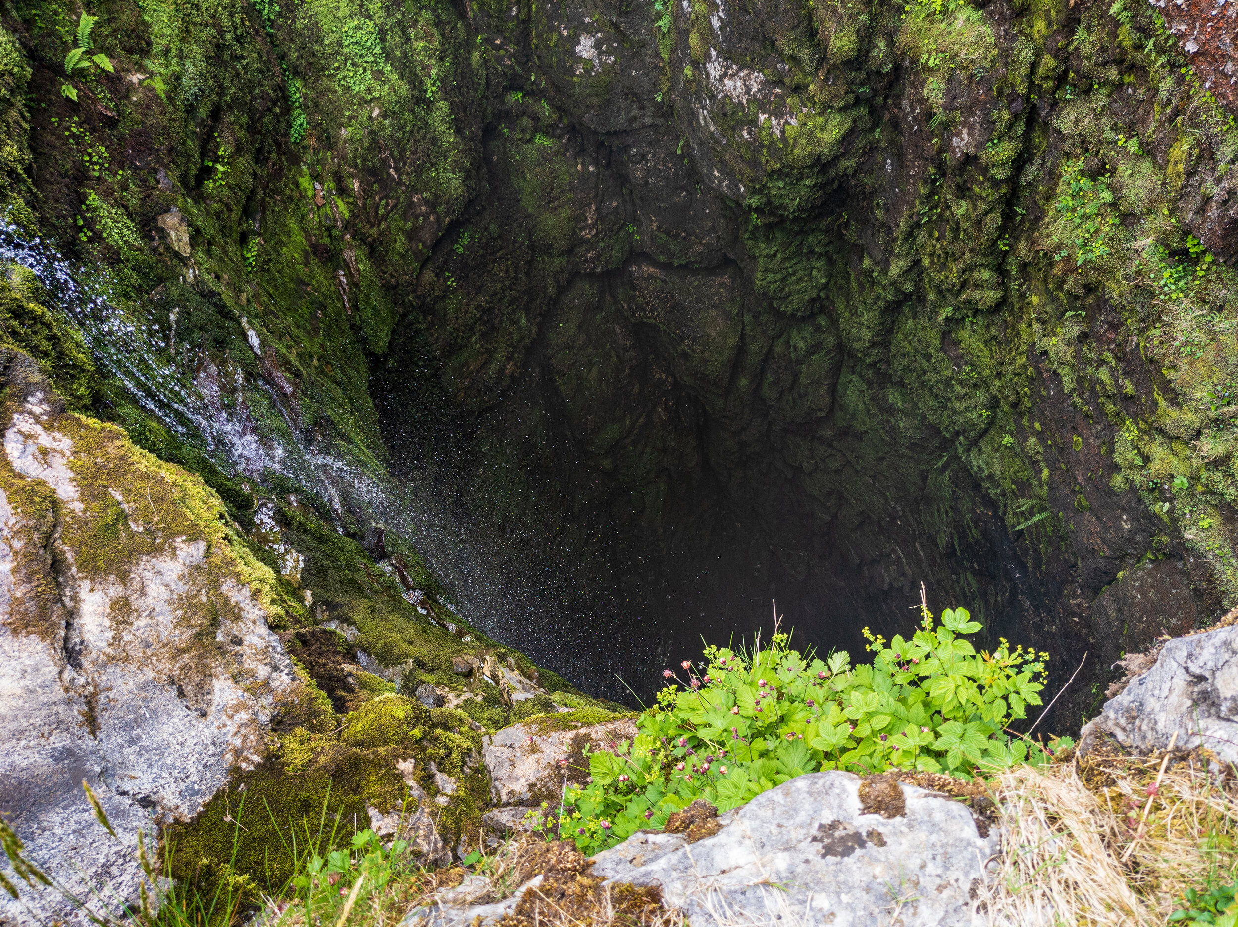
Looking into the abyss of Gaping Gill on Ingleborough
Each approach to Ingleborough offers something different, and starts from wildly different places, which is an important consideration when coming off the summit. Ingleborough catches more than its fair share of inclement weather, and with the summit often enveloped in cloud, navigation aids are essential to make sure you descend into the right valley!

A more typical view from the summit of Ingleborough
Many visitors will take the Y3P route from the East - probably the most dramatic approach over limestone pavement, leading to a steep, exposed ascent to the Col between Simon Fell and Ingleborough.

Heading to the summit from Simon Fell, Ingleborough is in the background
The route to the west, from Horton is longer than you would expect (catching out many a Y3P walker who thinks they are finished after Ingleborough), again passing through limestone pavement, though a lot less steep. A steady path from Ingleton, via Fell Lane is a popular option due to the relatively short distance from the town, and one of the least popular options is over Simon Fell, from Ribblehead.
My personal favourite is the approach from Clapham, via Trow Gill, but there are some many options, you’ll probably find yourself returning again and again.

Entering the enchanting Trow Gill


