OS Maps Premium Subscription Review

UPDATE 07/01/2022!
A lot can change in six months!
With the Viewranger app sadly being discontinued, the OS Maps app remains a viable and competent alternative. Ordnance Survey have also been busy updating the app and Web portal since this review, with the reliability of the GPS fix massively improved (it could be a coincidence, or an update to my phone’s software, but the tracking has been excellent over the past few months). An instant 8-figure grid reference is now available through a ‘tap and hold’ of the phone’s screen.
The brand new web app has also been launched, which is for now running alongside the old one. Seemingly a lot more user-friendly on the surface, much of the underlying functionality that made the original so popular remains, but with a slightly slicker skin. The 3D satellite view is both stunning and potentially a bit of a time-sink - prepare to lose many a long winter’s evening flying through the routes you’re planning for the summer.
There have sadly been reports of issues with printing to scale. The new OS help guides could be more… er… helpful here, as they don’t really seem to offer any advice. I found that ensuring I was printing to scale, and then selecting to remove the margins in the app’s print dialogue, while leaving the scale at ‘default’ managed to get the scale exactly right.
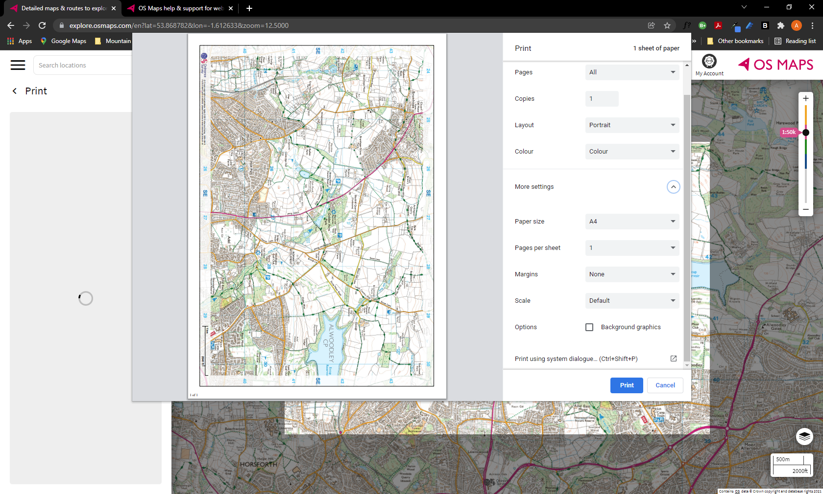
The ‘correct’ print settings
Perfect!
Original Review
There are now a number of options for real-time GPS mapping apps, making the outdoors more accessible than ever. While I’m still a big believer in navigating using a waterproof map and compass, and the benefits that can bring, there’s no denying the convenience of having accurate mapping data and your real-time position in the palm of your hands.
There are a few brands in this area who are doing this well…where better to start than the brand that almost every walker in the UK is familiar with: Ordnance Survey.
I’ve been using OS paper maps for years, and while there are other paper options out there, I’ve found their coverage to be fantastic, safety in their consistency (if you ignore the colour differences between the 1:25000 and 1:50000 maps), and great accuracy. Sure, there may be paths marked on the map which are now overgrown (and vice-versa - paths on the ground which aren’t on the map), and the occasional mix up between blue and black ink, but in all the times I’ve gotten slightly lost and wondered whether the map is inaccurate, or I’m not where I think I am, the map has been right. Like, 100% of the time.
So we’ve got a historic British brand and accurate maps that have been trusted for generations, now thrust into our palms via their own OS Map app.
A big winner for me in deciding to opt for OS maps is that pretty much every paper map sold in the past 5 years or so has come with a ‘digital download’ code - enter these into the app, and you get your map on the app for free, regardless of whether you’ve paid for a subscription or not. Curiously, the digital download is connected to a specific version of the map - if you have the 2014 version, say, this is the map that is downloaded. I can kind of see why they do this - they want you to keep buying new versions to offset the costs of physically needing to update the maps with what is happening on the ground, but it kind of also implies that they’re happy for you to follow an old (and potentially) changed map that may not be marked with more recent hazards, prioritising commercials over safety. It’s also not obvious that the map you have is not the most recent version - you need to check your downloaded version, and then the OS website to see the latest version to see whether they match or not. Not cool.
That said, it’s definitely a good hook to get you started, and if you’re like me, you start weighing up the costs of new maps (about £12 a time for the active versions which you really should be going for in our weather), against a £23.99 per year (at the time of writing) subscription for maps for the whole of the UK, the subscription starts to look like a good deal.
So, what do you get with the app?
First up, the mapping functionality is as good as we’d expect it to be. With an internet connection, you can zoom in on any area of the UK, from a regional view, to a street view, to the lower level Landranger and Explorer maps. The transition is automatic as you zoom through the levels, and you can select to either automatically transition between Landranger and Explorer as you zoom in, or to ‘lock’ the maps so that only one or the other appears when you zoom in far enough. If you’re used to working with one version or the other, I’d certainly recommend this.
At this point it’s worth mentioning the the Landranger and Explorer views are exclusive to the Premium subscription - free users who don’t have the digital download version for an area will see a simplified street view, showing roads, park/green areas, water features and contour lines. In National Parks, there is also an option to show ‘offroad walking routes’ - major paths in the park are marked with pink lines.
To round off the views options, there’s also a satellite view, green space view (helpfully highlighting open access areas in brown), and National Cycle Network view, showing all the cycle routes that make up the network.
It seems like the extra views are trying to compete in the free app space, giving enough information for casual walkers wanting to explore the National Parks via popular routes. But if you’ve paid for the subscription, you’ll probably spend most of your time in the Explorer and Landranger views.
The views themselves are an accurate replication of the paper maps, with one large caveat, which I’ll cover later.
A pink arrow shows your location, and orientation on the map, fixed by GPS (if active). Traditional setting of the map won’t usually work unless you turn auto-rotate off on your phone, but the directional arrow helps here. A compass readout is also available at the bottom of the map, indicating the bearing your phone is pointing towards. Curiously, the directional arrow and compass don’t quite line up - we’re talking about 5-10 degress difference, so it’s more than just magnetic variance.
A search function allows you to quickly locate places in the maps, and it seems to work with pretty much any place name entered on the map.
As you’d expect from a GPS app, you can plot a route in advance. The process is really simple, and the app works out distance covered, total ascent and the ascent profile for you, however it will always plot directly between the points marked, meaning you need to place a lot of points to get an accurate distance and height estimate. Still, the process is easier than planning on a paper map with Romer scale. I tend to use this to quickly get an estimate of the route length during expedition planning. The app will also display an estimated time - helpfully you can change the average walking speed in the settings (the default is a slightly ambitious 5km/h) and it takes into account the Naismith’s Rule, so additional ascent time is accounted for. It doesn’t take into account any breaks or wanderings obviously, so you’ll need to factor these in.
The plotted route shows on the map with a thick pink line. Thankfully you can change the colour, transparency and thickness of the line in the settings, so you shouldn’t be in a position where you can’t see underneath it.
There is also a social element to route-plotting, where you can connect to the service to find routes posted by others (complete with ratings). You can also choose to upload any routes that you record.
Personally, I don’t tend to follow pre-plotted routes on GPS, but the tool is very useful to get your walk timings right.
The final big ticket feature on the app is the Augmented Reality feature. This sort of tech has been around for a few years now, but it’s good to see Ordnance Survey connecting it to their vast database. AR mode activates your camera, labelling any features that are in front of you. In theory, this allows labels to be put against hills and towns in the distance, which is quite informative, even if it does take some of the fun out of working it out. It’s probably something that I’d take a while to trust if visibility were poor, but I can see how it would be very useful if proven in those circumstances.
Rounding off the feature set is a historic activity tracker and of course the full map legend for all the different map types.
So far, so good. However there are a couple of issues with the maps app - one that is fairly common across mapping apps, the other is one that just really bugs me.
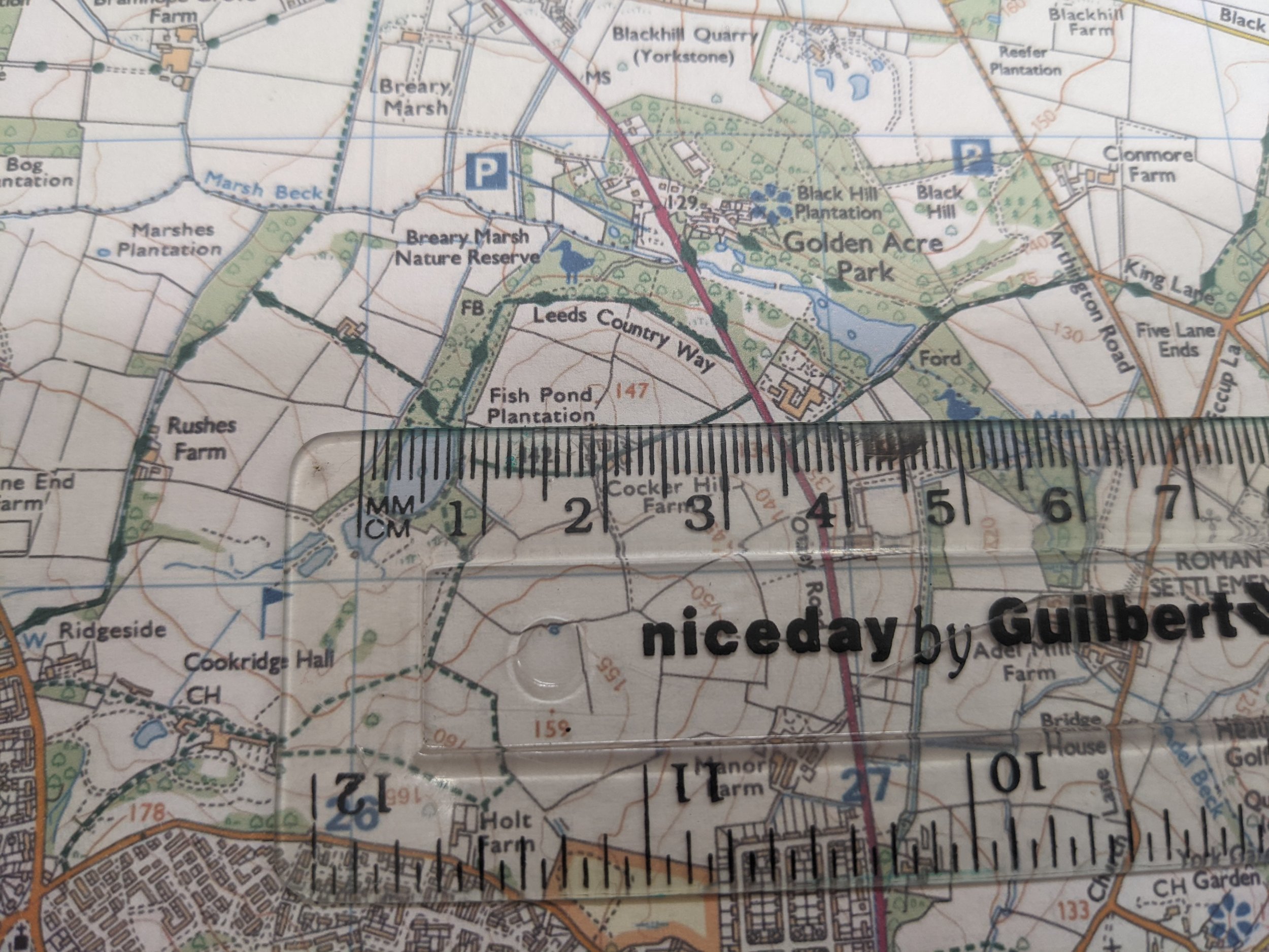
The first issue is that the nature of digital mapping means you can happily zoom in and out to fit more or less on your screen. And as a result of this, something that’s really obvious may not hit you until it’s stated explicitly: Once you add zoom to a 1:25000 scale map, it ceases to be a 1:25000 scale map.
Take the Explorer maps. On these maps, each square is 1km. On a paper map, the 1:25000 scale means that each square is 4cm across (1cm on the map is 250m on the ground). No matter where on the map, it’s always the same.
On the app, the size of each square on the map is dependent on your zoom level, your phone resolution and the screen size. In fact, on my Pixel 4, with the ‘Auto’ option on the OS map app, the only time the square measures 4cm is at a point just after (but not exactly) when it switches from Landranger to Explorer view. And trying to get it to be exactly the right scale is nearly impossible (unless there’s a hidden option somewhere), even using the pinpoint location feature, the zoom level is slightly off.
This causes two problems: The first is that it becomes difficult to measure distance using a Romer or reference card. For taking static grid references, this becomes pure guesswork. The frustrating thing is, it doesn’t need to be - there’s no option anywhere which gives you the 6-figure grid reference of your location. This feature is surely a no-brainer? (update 22/03/2022: Pressing and holding on the phone’s screen now brings up the grid reference - a welcome added feature)
The second part of this is that zooming in and out can confuse your sense of scale. It’s not a problem unique the this app - how many times have you used a in-car navigation at different zoom levels, and gone past a junction as it appears sooner than you expect it - but it can lead to under or overestimating distances, particularly if you’re not used to measuring distance on a map.
You can ‘think’ around these issues - just remind yourself to check the zoom level before judging distances. And if you’re following GPS, do you really need to measure on the Romer scale?
The second big issue, that honestly, I can’t understand why it works this way, is the behaviour of the app when it fails to get a GPS fix. With my preference for map/compass navigation, I would typically use my phone and the OS map app as a GPS backup, and also to record my route for later upload to my walking logbook and Strava. When I reviewed my routes later, I found that on almost every single walk, a spike would appear in the route - a straight line, sometimes miles off the route, then a return from that point to a little further down the route. What’s happening here is that the GPS fix is being lost, and as a backup behaviour, the app is programmed to relocate from the nearest mobile mast. In the hills and mountains, masts can be miles away (you’re high up, with a clear line of sight to the mast), so the route ‘spike’ is significant.
I’ve checked the menus and as far as I can see there is NO WAY to turn this off, without disabling the mobile network on your phone. This makes the GPS recordings near-useless as the last thing I want to do is spend time editing these points out of the GPS files (I spend enough time editing files where I forget to hit ‘stop’ before driving off).
To be clear the root cause of this isn’t the app’s fault - the GPS fix is partly down to the phone, and partly down to where you carry it, but the way it handles the issue is mad. I’d much rather the behaviour in the app defualted to missing the points where GPS is lost, and then plotting a straight line from the last known position to the point GPS is re-established. Not perfect, but it would be a lot more accurate.
Surely this is something that OS will fix in a future update, but right now, it makes the experience frustrating. (update 22/03/2022: I haven’t seen confirmation about whether this has been fixed, but I’ve not noticed this behaviour now for the past months - the GPS fix appears to either be more reliable, or the app is handling it better)
All in all, this app has been a bit of a game changer. Do I use it? I did for a while, and it stopped me making a couple of navigational errors during my training, where I would have ended up quite far off course. But personally (and this is just me), I feel that following a GPS, whether in the car or on the hill, disconnects me from my surroundings. I don’t need to be aware of what is around me to navigate as the app is doing the heavy lifting. Which, in a car is fine, if you just care about getting to your destination. But when you’re out on a walk, surely you want to experience the journey, rather than watch it unfold on a screen.
I’m also very aware of the need to keep my navigation skills sharp, and I can feel them fading if I use the app for a few weeks.
But, and here’s the big one: Used in the right way, with the right safety precautions, and interpreted correctly, it makes the outdoors much more accessible for people, which has to be a good thing.
For me, I still use this as my GPS backup, but I’ve outsourced route recording to my watch. Worth the money? Absolutely, but it could be great if the niggles are addressed.
Before I finish off, I also want to mention the OS Maps website. As a premium subscriber, you get access to the online maps on your PC also, however here there are two very powerful additional features.
The first is the ability to print a map. Connected to a decent printer, and with special weather-proof paper, you can create your own custom paper maps (at the correct scale too!). This is absolutely incredible…
Secondly, the route plotting features on the website are superior to the app. An option exists to ‘snap’ to a path/right of way, so plotting points will follow the best path. Not only this, but it can be toggled on and off for EACH point plotted - so, for example, you can use the route plotter to work out the best route to access land, and then plot a direct off-path route, before snapping to paths again on the descent. Each waypoint also comes with an 8 figure grid reference.
Pros:
All of the OS maps in the UK at your fingertips, with added GPS
Good AR feature and search function
Takes the pain out of route plotting, particularly on the website
You can print your own maps
Cons:
App depends on the health of your phone/connection
Frustrating behaviour when GPS fix is lost during route recording (reliability now appears to have improved)
Rating: 4/5
You can get the OS Maps Premium Subscription here.
NOTE: I’m planning a future article that will go into this in more detail, but I wanted to add this here as it is an important safety concern.
If you are relying solely on the app for navigation in the countryside, you need to ensure it is reliable. Two things that could easily go wrong are:
You can’t download map information from the server as you haven’t got an internet connection. No download = NO MAP
Your phone battery runs out (due to forgetting to charge it, poor battery or battery life shortened by the cold). No power = NO MAP
As a minimum, I’d make sure you:
Carry a paper map backup of the area (you can print off area maps from the OS website, as a Premium subscriber)
Download the map to your phone of the area you are walking in, so it doesn’t need an internet connection to function (Menu > Offline Maps > Offline Maps > Add a custom offline map)
Pack a FULLY CHARGED power pack which is capable of charging your phone battery fully, plus your charging cable


